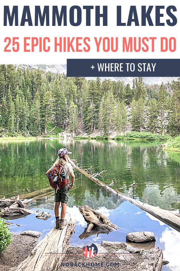
Mammoth Lakes in the Eastern Sierras is an outdoor adventurer’s year round playground. From skiing in the winter, hot springs and a variety of Mammoth Lakes hikes the rest of the year, there is no shortage of fun. With everyone looking for safe outdoor fun these days, we have compiled a list of our favorite Mammoth Lakes hikes that all ages can enjoy. There are an unlimited number of amazing hikes to do from multi-day treks to simple lake walks. There really is a trail (or few) for everyone no matter your fitness level.
The combination of majestic mountains, lakes and relatively cool summer weather make hiking in Mammoth Lakes one of our favorite things to do every year. Not to mention that this is also where two of the most famous California trails pass through. The John Muir Trail goes from Yosemite Valley to Mount Whitney passing near to Mammoth Lakes (more specifically Devil’s Postpile) which is also near to where the famous Mexico to Canada Pacific Crest Trail goes.
Below I outline some of our favorite hikes in Mammoth Lakes by area to help you plan your next visit.
Don’t forget to check out all the other amazing things to do in Mammoth while you are in town!
Disclosure: Some of the links in this post are affiliate links, meaning at no additional cost to you, I will earn a commission if you click through and make a purchase.
Jump to a Heading Below
Where is Mammoth Lakes?
 Mammoth Lakes is located in the Eastern Sierra Nevada region of Northern California. For those of you not familiar with the area, it is essentially on the other side of Yosemite National Park. Mammoth Lakes is the official name of the town, but you might also hear it called just Mammoth or Mammoth Mountain.
The drive to Mammoth from Los Angeles is about 5 hours, 7 hours from San Diego, and 6 hours from San Francisco cutting through Yosemite (which is not an easy option for 2021). The location makes it a great getaway for a great swath of the state. Lastly, for those of you who don’t want to drive, there are also flights available at the small local Mammoth Yosemite airport.
Pro Tip: If you are driving up from the Los Angeles area, make sure to plan some time to explore Highway 395 on your way.
Tips for Hiking in Mammoth Lakes
Mammoth is a serene destination, drawing tourists from all over California, the United States and from throughout the world. To help keep Mammoth Lakes beautiful, keep you safe and help you enjoy your visit to the maximum, here are some of our top tips to consider while planning your trip or while in town.
- This is bear country. Do not leave food in your car overnight or at busy bear spots. Pack your food in bear-proof bags, bear containers or at the least a cooler.
- Download trail maps before heading out as cell service is spotty on most trails. (We use AllTrails and love it).
- Pack a lunch and bring snacks with you as hikes can take much longer than you anticipate. Outside of town, there are few places to eat.
- Tell someone which trails you plan to do or consider carrying a GPS sat device in case of emergencies.
- Bring reusable water bottles, water reservoirs and snack containers to reduce trash in the area.
- Keep a water cooler in your car to refill your water bottles as you go.
- Take public transport and the free shuttles to help reduce your carbon footprint and traffic in town and tourist hot spots.
- To combat altitude sickness, drink electrolytes and plenty of water BEFORE you arrive and during your visit.
- Keep plenty of bug spray and sunscreen on hand for summer months. It is buggy and sunny!
Want to know what other things to do in Mammoth Lakes? Check out my post, 21 Magical Things To Do In Mammoth Lakes!
Managing the Altitude
Mammoth Lakes the town sits at 7,880 feet in altitude, but on many of the hikes, altitudes can reach up to more than 11,000 feet. The Lakes Basin area starts at around 9,000 feet in altitude before you even start hiking!
Altitude sickness does not affect everyone the same way. For many people they may only notice a bit of breathlessness when walking and hiking, for others it’s a real issue that can be debilitating.
What exactly are the symptoms of altitude sickness?
The symptoms of altitude sickness can range from mild to severe headaches, nausea, shortness of breath, fatigue and difficulty sleeping.
For most people, symptoms of altitude sickness can begin within a few hours of getting to higher elevation. However, we have seen it happen several times that it takes a little longer to really notice or that the symptoms come and go.
How to Prepare & Feel Your Best
In our experience, the best thing to do to prepare to go into higher altitudes is to hydrate very well. We typically drink electrolyte drinks for the 24 hours prior to visiting higher elevations. If possible continue to drink at least one electrolyte drink per day while in high altitude as well to help keep any symptoms away. This is especially true in the summer months in Mammoth where it may not feel too hot, but is often very dry. We love these electrolytes after trying just about everything out there!
Additionally, avoid alcohol, drink a ton of water (3-4 liters a day), eat more carbs and go up in elevation slowly. If you experience symptoms that are not reducing with water, electrolytes or pain reliever medication, get down to lower elevations.
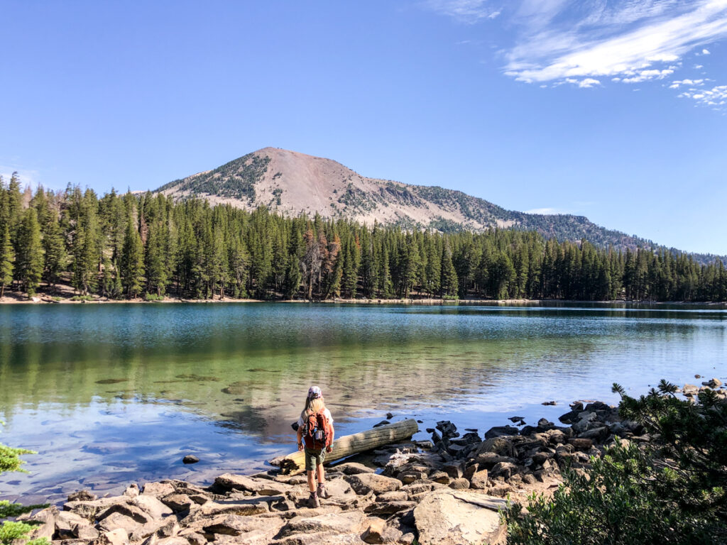
Lakes Basin Area Mammoth Lakes Hikes
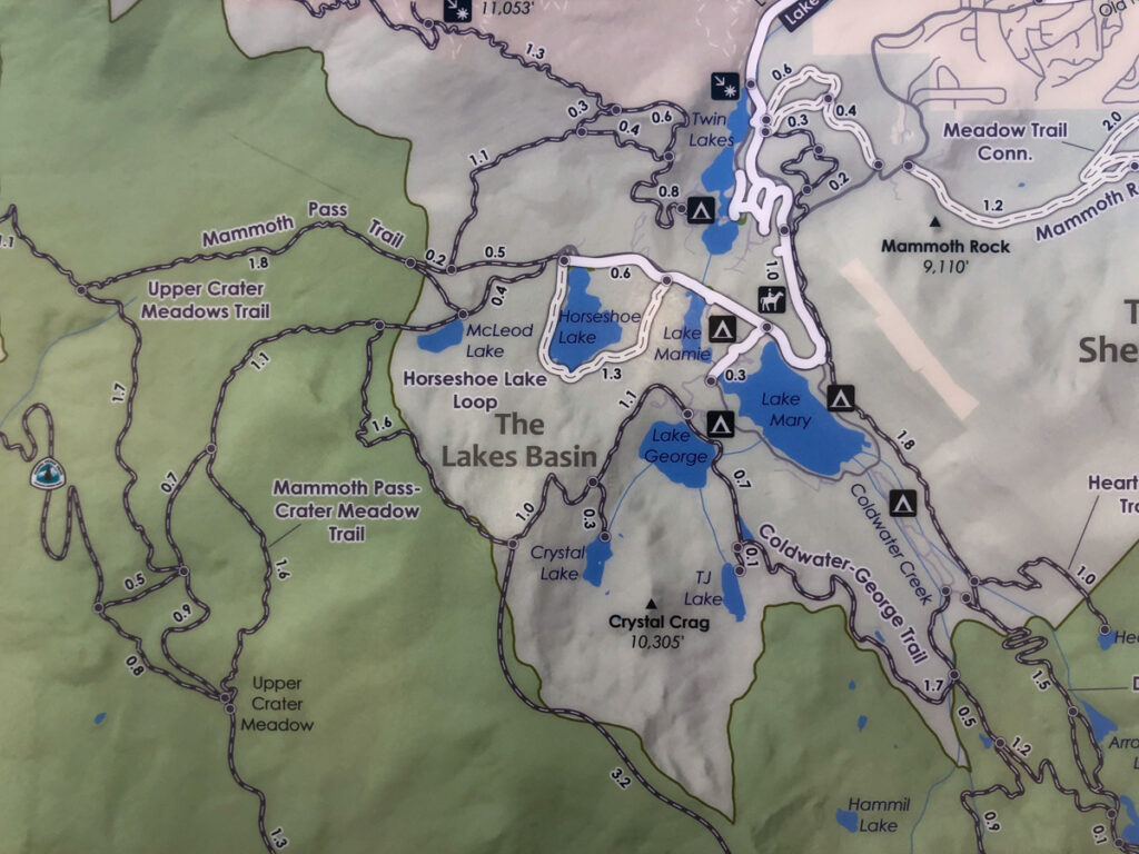 The Lakes Basin area of Mammoth is one of the best areas for first time visitors and well seasoned hikers alike. Here you will find a myriad of trails for both hiking, biking and numerous lakes perfect for a day of fishing. This is your best bet for one stop hiking. You can easily take the summer trolly up to this area in the morning and spend the entire day hiking between all the various trails and lakes.
Twin Lakes
Nestled at 8,600 feet, Twin Lakes is the lowest lake in the Lakes Basin. Situated a bit away from the bulk of the other trails, Twin Lakes is located between Panorama Dome and the southern part of Mammoth Mountain. As far as hiking goes, the trails here are quite short. There is a .3 mile hike along the lake front that offers nice views. I would not call this a hike, rather a spot to check out while in the area.
However, for those on bikes, particularly if you are riding the Lakes Basin Path, this is a great spot to stop for a breather and enjoy the water.
McLeod Lake
McLeod Lake is actually one of our favorite trails in the Lakes Basin area. This trail is at the very end of the trolly route and at the end of the road. This short hike takes you up to a favorite fly fishing lake with staggering views of the Mammoth Crest which is above the lake. This trail is only about 1 mile round trip, with a slight incline. We recommend connecting off the main trail after you have explored around the lake to the Horseshoe Lake trail. Make sure to download the trail map for the area on your All Trails so that you can keep up with what trail you are on and to be certain you aren’t heading off in the wrong direction.
Heart Lake Trail
Heart Lake is another great option in the Lakes Basin and is an off-the-beaten-path hiking destination. The 2.25-mile round trip leads hikers through aspens groves to the heart-shaped lake tucked beneath the west side of Sherwin Ridge. While this hike is accessed from the parking area at Coldwater Campground, it is surprisingly empty for the most part. The lake is beautiful, shallow in areas making it a perfect spot to come hang out for the day with a picnic and swimsuits! On your way up, check out the Consolidated Mine at the base of the trail.
Horseshoe Lake Loop
One of the easiest and more popular hikes in town is Horseshoe Lake Loop. This 1.7 mile path along the shore of the lake is popular for hiking and for mountain biking. If you are going car free, take the trolley to stop 104. If you are planning to visit McLeod Lake, you can combine these two for 3-5 miles total. If I had to pick a favorite trail in this area, I would choose this one for it’s cute bridges, stream crossings and beach access.
Lake Mary
The Lake Mary loop is not actually a hike per se, more of a walk around the lake. The full loop is only about 2.5 miles long with minimal elevation gain making a great option to get out and stretch your legs in the evening after dinner at one of the local campgrounds. While you are here, you can also rent kayaks or SUPs from either end of the lake. We recommend going early in the day as the water tends to be a bit calmer in the morning.
Lake George Trail
The hike around Lake George is a relatively simple 1.5-mile loop with about 104 feet elevation gain. It isn’t classified as easy because there are some sections that you have to climb through bushes and over rocks. It is an adventure though! To make a bit more of this hike, combine it with the following lakes TJ and Barrett.
TJ Lake & Barrett Lake
If you are in the Lake George area and looking for a lowkey hike, check out TJ and Barrett Lakes from the Lake George Trailhead. This is a 1.5 mile round trip that is rated as easy.
Skelton Lake
Skelton Lake is one of the many lakes you will pass while hiking the Duck Lake Trail. However for those that don’t have the energy or ability to hike 10.5 miles to Duck Lake, this 3.1 mile hike is a good option. Starting in Coldwater Campground area, this hike is roughly 1.5 miles one way from the trailhead parking lot with over 770 feet of elevation gain. If you’re feeling brave, this is a cool place to hike to at night for some night photography.
Crystal Lake
Crystal Lake is one of the most scenic hikes in the Lakes Basin area with bird’s eye views of the lakes below and the 10,700-foot Crystal Crag as a backdrop. It is a popular trail, even though it is considered to be moderate. What is moderate about it is that it climbs straight up hill more than 600 feet in less than a mile making it a bit tough on the lungs and legs! The 3.1-mile hike starts from Lake George and can take 2-3 hours roundtrip. Overall this in/out hike can be done by most people as long as you take it slowly, have plenty of water and sun protection. Take the Mammoth Lake Trail to the Crystal Crest Trail.
Emerald Lake Trail
The trail to Emerald Lake is a popular trail well worth the bit of incline and people you will see along the way. Emerald Lake is overall an easy hike at about 1 mile starting from the Duck’s Pass trailhead at the end of Coldwater Campground. This trail is slightly uphill along a wide dirt path. Once you reach Emerald Lake you can relax for a bit or decide to head on up a few other trails for more exploration.
Sky Meadow Waterfall Trail
My absolute favorite trail in the Lakes Basin area is Sky Meadow which is just after the Emerald Lake. If you go past the lake, you will see a sign leading you either to Ducks Pass or to Sky Meadow. We recommend going to Sky Meadow. This beautiful trail follows along a bubbling creek up to 2 different meadows. But what is even better about this trail is the beautiful waterfall you will encounter right before Sky Meadow. The entire trail is uphill, but it is worth the effort.
Duck Lake and Pika Lake
Probably one of the most beautiful hikes in the Mammoth Lakes area is the one to Duck and Pika Lakes. This is a long hike clocking in at around 10.5 miles, so if you can finagle permits, consider doing it as a backpacking trip. Regardless how you do this hike, you will pass 5 lakes total including: Arrowhead, Skelton, Barney, Duck, and Pika. This isn’t an easy trail however with 2,000 feet of elevation gain over the 5 miles up.
Panorama Dome Trail
Located near Twin Lakes, this is a fun out and back trail that has epic views and is only 0.7 miles round trip with roughly 300 feet of gain. If you happen to be staying across the road at the Twin Lakes campgrounds or riding on the Lakes Basin Bike Path, give a quick visit to check out the views.
Mammoth Crest Trail
One of the longest hikes on this list is the Mammoth Crest Trail. This is often done a bit in mistake as it’s the same trail leading to Crystal Lake, but on a different spur – the one going uphill! This 7+ strenuous mile hike leads hikers up to exceptional vistas over the John Muir Wilderness. Starting at the north end of the Lake George parking area, the trail climbs quickly in a series of switchbacks past the junction to Crystal Lake through a pine forest, topping out at timberline and the long, open ridgeline along the Mammoth Crest. Go as far as you can and then return back the way you started.
Hikes in the Reds Meadow / Devil’s Postpile Area
NOTE: For Summer 2024, the road to Reds Meadow is closed except on Friday, Saturday and Sunday. All other regulations still apply – arrive before 7 am to drive your own car, otherwise your only option is to take the shuttle.
Another popular area for hiking is in the Reds Meadow and Devil’s Postpile area of Mammoth Lakes which is home to both the Ansel Adams and John Muir Wilderness areas. During the summer the road to this area is restricted access meaning that you cannot drive on the road after 7 a.m. unless you have camping or hotel reservations. Since that is the case, we highly recommend you get up early, pack a breakfast and a lunch and go for the day to take in as many sights as you can.
Otherwise, hop on the Reds Meadow shuttle at Mammoth Mountain’s Main Lodge and enjoy the ride into the valley.
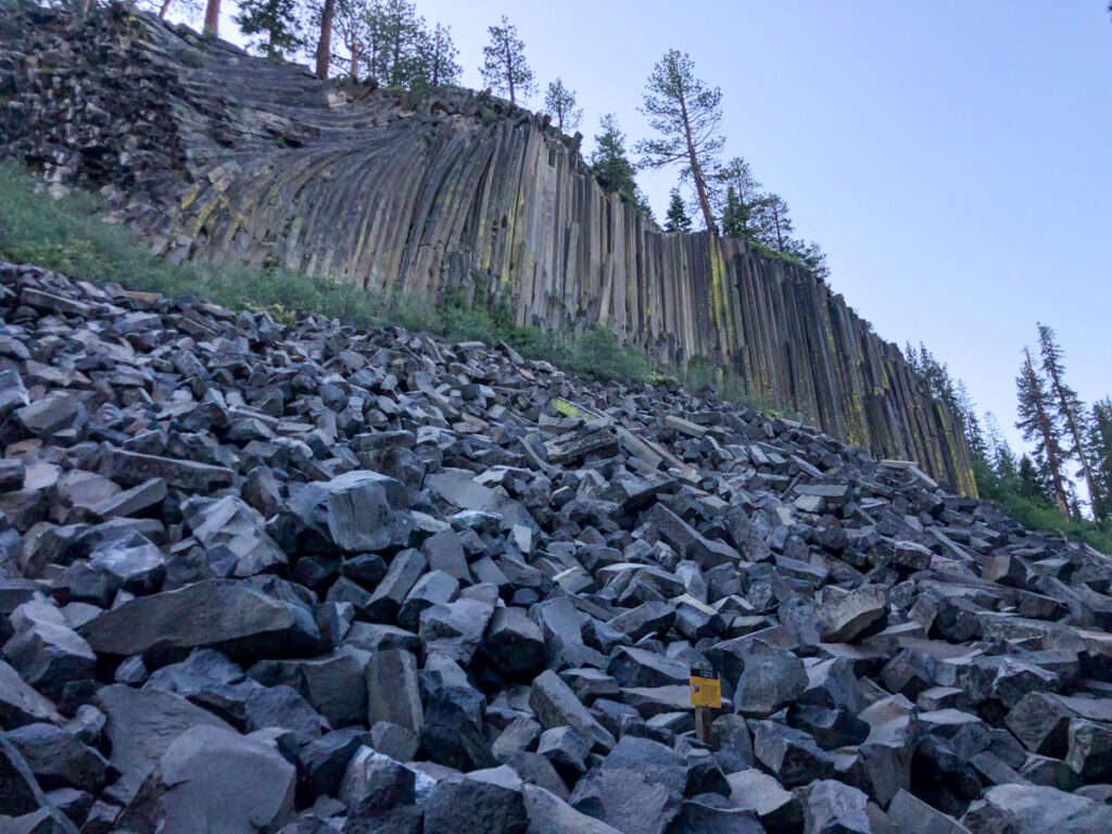
Devils Postpile
Devils Postpile National Monument is a true wonder to behold. The basalt rock columns are fascinating to observe from both the bottom and the top. The hike to Devils Postpile is only .8 mile, with a bit more to go to the top.
Rainbow Falls
While you are at Devils Postpile National Monument, you might as well take in a few other trails. The most popular trail here to combine with Devils Postpile is the Rainbow Falls Trail. This is a 1.7 popular in/out trail that starts at the visitor center (or after Devils Postpile), but combined with Devils Postpile ends up around 5 miles.
This trail is relatively flat and weaves through the John Muir Wilderness as well as the Ansel Adams Wilderness Areas.
The weather can be quite temperamental here with chilly cold mornings and extremely hot afternoons. Plan for both and be prepared with plenty of water and snacks.
For those with even more stamina, consider heading down to the Lower Rainbow Falls area which is an additional 1 mile each way with about 450 feet of elevation gain making the total hike closer to 7 miles.
Heading back to the car you could also take the JMT trail which crosses the river before leading you back to the start of the trail near the Minaret Falls turnoff. Note this adds about .8 of a mile to the total.
Minaret Falls Via The Minaret Falls Trail
Another great option while you are visiting Devils Postpile is the Minaret Falls hike. This will get you out on the PCT and JMT. This trail crosses a few streams and is around 2.6 miles with minimal elevation gain. This is a great spot for a bit of lunch and chill out time as most visitors head towards Rainbow Falls leaving this trail much quieter.
Thousand Island Lake Trail
One that is often more suited for backpacking, but can be done as a day hike is to Thousand Islands Lakes hiking trail. This trail can be accessed from the Agnew Meadows Trailhead which is on the way down to Devils Postpile, but not all the way down the valley. It is about 16 miles total, which is why many people do this as an overnight backpacking trip. Permits can be reserved at recreation.gov.
Shadow & Ediza Lakes Trail
The stunning 13 mile out and back Shadow and Ediza Lakes Trail in Mammoth offers serene views, along the bubbling San Joaquin river. This is a strenuous day hike, but is perfect for overnight backpacking. The trailhead is at Agnew Meadows like the Thousand Island Lakes trail above. To drive down, you must get past the Minaret Vista station before 7 a.m., otherwise you will need to take the shuttle from Mammoth Mountain Adventure Center.
Sotcher Lake Loop
 While you are down in the Reds Meadow area, there are other places to check out. Sotcher Lake Loop is a short 1.5 mile hike (a short walk from stop #7 on the Reds Meadow Shuttle) which is pretty mellow. This is a popular and easy self-guided nature trail perfect for families. The trail will provide an introduction to flora, fauna and geology of the area.
Starkweather Lake
Lastly, for those who just haven’t had enough, another beautiful lake hike down in this area is the Starkweather Lake. You can hike here from Minaret Vista or just complete the loop around the lake. This is the smaller of the 2 lakes in the Reds Meadow Valley, located at stop 2 on the Reds Meadow Valley shuttle. The fishing is said to be more productive here than at Sotcher Lake as well!
Other Mammoth Lakes Hikes
Mammoth Rock Trail
The Mammoth Rock Trail is a classic Mammoth hike with epic views of Mammoth Rock and the town of Mammoth. It’s just slightly over 5 miles round trip with about 650 feet of elevation gain. It can get pretty hot in the summer due to lack of tree coverage, so come prepared.
Sherwin Lake Trail
The Sherwin Lake Trail is one of the few trails with a lower elevation, but still offering aspen groves and old growth Jeffrey Pines. Located on the other side of Mammoth than the Lakes Basin Area, the trail climbs steeply in a series of switchbacks to a small plateau and a pair of small lakes beneath the high peaks of the Sherwin Range, affording wide vistas back across the town of Mammoth Lakes and the Long Valley Caldera.
Hikes to Consider Outside of Mammoth Lakes
While there are a ton of great hikes in Mammoth Lakes itself, you might ask why I would want to recommend hikes outside of town. I get you, but I would be remiss if I left off one of the most beautiful hikes that can easily be visited on your way into or out of town.
Convict Lake Loop
One of the most picturesque lakes in the area, Convict Lake offers a loop trail around the lake and is quintessential Eastern Sierra! This 2 mile trail is gentle and flat making it easy for all ages. While you are here, take some time to explore the area from the water with rentals for kayaks, pontoon boats and more.
Little Lakes Valley Trail to Gem Lake
Even though there are a ton of trails close to Mammoth Lakes, one of the best in the area is just 30 minutes away at the Mosquito Flat trailhead in Rock Creek Canyon. One of the best first timer backpacking hikes in the Rock Creek Canyon area is Little Lakes Valley Trail which offers alpine lakes and mountain peaks. Take the trail all the way to Gem Lake for a 7-mile round trip, or turn-around at any point for your desired length. This trailhead is located about 45 minutes from Mammoth making it great as a day trip or on your way into or out of town. Note, this trail begins at 10,000 feet before you even start hiking.
To find out more about these hikes and other hikes in Mammoth Lakes, check out the Mammoth Lakes Trail System website.
Where to Stay in Mammoth Lakes
There are a ton of places to stay in Mammoth, mostly centered around camping and Airbnb stays. Below are a few hotel options and campgrounds to get you started on your search.
The Village Lodge – A great choice for those planning to ski in the winter as the lift is right next door!
The Westin Monache Resort – Arguably the best place to stay in town, located right in the middle of the Village.
Tamarack Lodge – Located right along Twin Lakes next to the campground, offering unique cabin options.
Reds Meadow Lodge – There are a ton of amazing Mammoth area hikes that start from this area including some on the John Muir Trail and the Pacific Crest Trail.
If you rather stay in your own place, Airbnbs are all over. For the most part you can’t go wrong. If you don’t want to drive much, try to get one near one of the many trolley lines that can then take you all over town easily. Our hot tip is to always try to find units that have hot tubs and/or pools available during your visit. Note that many do NOT have AC and it can get toasty in the summer.
Campgrounds in Mammoth Lakes
It would take an entire post just to list all of the options, but below we share the top spots that are great for access to town and nature.
Lake Mary Campground – Located in the Lakes Basin area and is right opposite the lake across the road. It is busy, but convenient.
Coldwater Campground – This is located above Lake Mary a bit with easy access to hikes to Emerald Lake, Ducks Pass and Heart Lake. A large, busy campground, with ample space.
Twin Lakes Campground – There are two campgrounds here that are shady and just along the Twin Lakes near the Tamarack Lodge. Easy access to the Lakes Basin Bike Path and to town or the Lakes Basin area.
Lake George Recreation Area – Located on the shores of Lake George, this is a more secluded campground, not on the trolley path, but great location.
Convict Lake – Located outside of Mammoth a bit offers more of a nature feel, less easy access to town.
June Lake – There are a handful of campgrounds around June Lake, but this is one of the more popular ones.
Silver Lake – Another campground along the June Lake Loop area.
If You Enjoyed This Post, Sign Up To Receive Posts By Email or…
- Join us on Facebook for regular updates and related articles
- Check us out on Instagram to see what we are up to in photos
- Follow us on Twitter for links to great travel articles curated just for you
- Or share this post with others by pinning on Pinterest!